Northumbrian Climbing Guide |
||||||||||
|
|
|
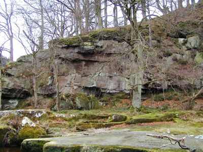
| Thrum Mill | What the symbols & colours mean |
| Grid Ref: NU068015 Aspect: N Routes: 6 Max Length: 10 Average Length: 8 | |
| Altitude: 0 mtrs Walk in: 0 mins Bouldering quality: poor |
      3 | Click here for StreetMap |  | |
There is no legitimate access along the river bank from either direction. The caravan park to the west is private The easiest access is from the end of the trading estate on the south side of Rothbury. You can cross the fence at the north eastern corner of this estate and get down through the wood to the crag. Alternately, you can brave the river. Park in the large lay-by at the bottom of the hill going into Rothbury along the B6344 from the east and head down the public bridleway to Thrum Mill and Rothbury. The crag is situated where the river narrows to a few feet. Look carefully at the crag and decide for yourself if it is worth the leap over the narrows or the plodge through the shallows upstream. | |||
General:
The crag is on bluff on a bend of the Coquet, with copious amounts of vegetation encroaching on the finishes of the routes and is rather typical for quarried sandstone.. It is directly opposite Thrum Mill, a popular tourist spot at a point where the Coquet flows through a rocky channel a few feet wide. There is a clean buttress of 10 meters at the eastern end and other taller but more overgrown buttresses further upstream. A fine place for posing.
Rock:
Fell Sandstone Carboniferous, Dinantian
History:
The routes and descriptions in this guide are the work of Simon Gee and Lewis Grundy and were done during 1991. Rumours of previous visits by G. Thompson are vigorously denied. |