Northumbrian Climbing Guide |
||||||||||
|
|
|
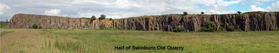
| Swinburne Old Quarry | What the symbols & colours mean |
| Grid Ref: NY919754 Aspect: N Routes: 41 Max Length: 22 Average Length: 12 | |
| Altitude: 140 mtrs Walk in: 25 mins Bike in: 5 mins Bike out: 5 mins Bouldering quality: poor |
      14 | Click here for StreetMap | ||
The quarry is a 1km walk along a private quarry road from the A68, 7.5 miles south of West Woodburn. The road is signposted to Barrasford Quarry. This is not a right of way. | |||
General:
An impressive looking Whin Sill quarry with few natural lines and much loose rock. Protection is poor and there are hardly any belays available at the top. On a warm summers day this used to be a pleasant spot to lounge around and practice your loose rock technique, but nowadays the quarry is used as winter shelter for cattle which have not been toilet trained. Avoid springtime like the plague, which you would risk contracting. By July it's all nice and green.
Rock:
Whinstone Quartz Dolerite, Permo-Carboniferous Quarried whinstone. Not the worst, good in places, but where it's bad it's very bad. Access issues:
There is no right of way and permission to use the described approach has been denied (informally via phone to local office)
Routes/Bouldering:
Routes:
Not brilliant, but surprisingly there are some good ones. Unfortunately I can't remember which. No recorded problems.
History:
Steve Belk did a suicidal groove at the left hand end of the quarry in the 60's and G Thompson and J Dalrymple did a few routes at around the same era. G Thompson produced a homespun guide. Karl, Simon and Graham Telfer did some routes during May 1986, but precisely which did what is not recorded, so all three are accredited with each of their routes. |